Property Record
19 Superior Dr Se, Rome, GA 30161

NEARBY LISTINGS FOR SALE OR LEASE
-
-
View all Rome listings for sale on LoopNet.com
Property Detail
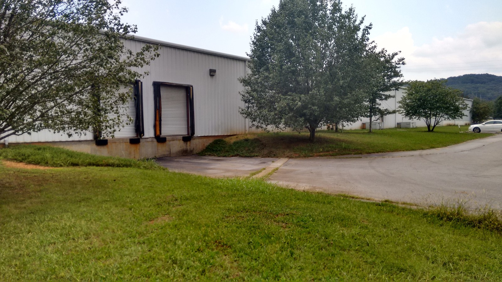
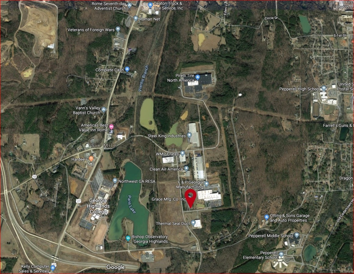
19 Superior Dr Se
Rome, GA
Industrial Park Ph 1
I17W-003
Floyd
Warehouse
Georgia
X
5.05 AC
13115C0287F
Georgia Northwest
30,000 SF
Other Market Areas
DEMOGRAPHICS near 19 Superior Dr Se
1 Mile
3 Mile
5 Mile
2024 Total Population
1,221
7,965
23,344
2029 Population
1,253
8,124
23,932
Pop Growth 2024-2029
+ 2.62%
+ 2.00%
+ 2.52%
Average Age
40
40
40
2024 Total Households
373
2,875
8,783
HH Growth 2024-2029
+ 2.95%
+ 1.98%
+ 2.58%
Median Household Inc
$56,499
$53,759
$51,875
Avg Household Size
2.60
2.50
2.50
2024 Avg HH Vehicles
2.00
2.00
2.00
Median Home Value
$156,081
$161,374
$178,594
Median Year Built
1974
1970
1977
Nearby Places
- Restaurants
- Banks
- Shops
- Fitness
- Groceries
SALE & LEASE HISTORY
LISTING DATE
SALE/LEASE

Sep 08, 2017
For Sale
Jun 11, 2018
For Sale
Aug 12, 2019
For Sale
Aug 08, 2023
For Sale
Nearby Properties
Address
Land Use
TOTAL SIZE
Lot Size
Zoning
Address
Land Use
TOTAL SIZE
Lot Size
Zoning
425,450 SF
127.78 AC
H-I
Address
Land Use
TOTAL SIZE
Lot Size
Zoning
62,832 SF
H-I
Address
Land Use
TOTAL SIZE
Lot Size
Zoning
203,082 SF
22.05 AC
H-I
Address
Land Use
TOTAL SIZE
Lot Size
Zoning
260,476 SF
51 AC
H-I
Address
Land Use
TOTAL SIZE
Lot Size
Zoning
231,750 SF
25 AC
H-I
Address
Land Use
TOTAL SIZE
Lot Size
Zoning
223.90 AC
O-I
Address
Land Use
TOTAL SIZE
Lot Size
Zoning
42,744 SF
11.10 AC
S-R
Address
Land Use
TOTAL SIZE
Lot Size
Zoning
15.20 AC
O-I
Address
Land Use
TOTAL SIZE
Lot Size
Zoning
257,573 SF
25.64 AC
H-I
Address
Land Use
TOTAL SIZE
Lot Size
Zoning
46,176 SF
9.88 AC
H-I
Address
Land Use
TOTAL SIZE
Lot Size
Zoning
79,954 SF
17.73 AC
H-I
Address
Land Use
TOTAL SIZE
Lot Size
Zoning
81,320 SF
28.66 AC
H-I
Address
Land Use
TOTAL SIZE
Lot Size
Zoning
72,000 SF
10 AC
Address
Land Use
TOTAL SIZE
Lot Size
Zoning
16 AC
O-I
Address
Land Use
TOTAL SIZE
Lot Size
Zoning
98,280 SF
7.90 AC
H-I
Address
Land Use
TOTAL SIZE
Lot Size
Zoning
50,221 SF
19 AC
L-I
Address
Land Use
TOTAL SIZE
Lot Size
Zoning
1 SF
171.76 AC
Address
Land Use
TOTAL SIZE
Lot Size
Zoning
11,400 SF
12 AC
H-I
Address
Land Use
TOTAL SIZE
Lot Size
Zoning
163,425 SF
6.80 AC
H-I
Address
Land Use
TOTAL SIZE
Lot Size
Zoning
24,750 SF
8.37 AC
H-I
Address
Land Use
TOTAL SIZE
Lot Size
Zoning
42,900 SF
12.07 AC
H-I
Address
Land Use
TOTAL SIZE
Lot Size
Zoning
758.13 AC
Address
Land Use
TOTAL SIZE
Lot Size
Zoning
70,200 SF
7.73 AC
H-I
Address
Land Use
TOTAL SIZE
Lot Size
Zoning
20,000 SF
1.99 AC
H-I
Address
Land Use
TOTAL SIZE
Lot Size
Zoning
4,800 SF
295.23 AC
A-R; S-R
Address
Land Use
TOTAL SIZE
Lot Size
Zoning
13,280 SF
1 AC
C-C
Address
Land Use
TOTAL SIZE
Lot Size
Zoning
3,793 SF
1.59 AC
C-C
Address
Land Use
TOTAL SIZE
Lot Size
Zoning
8.63 AC
H-I
Address
Land Use
TOTAL SIZE
Lot Size
Zoning
87,618 SF
25.60 AC
L-I
Address
Land Use
TOTAL SIZE
Lot Size
Zoning
60,300 SF
6.60 AC
L-I
The World's #1 Commercial Real Estate Marketplace
Connect with us
© 2025 CoStar Group
The information above has been obtained from sources believed reliable. While we do not doubt its accuracy we have not verified it and make no guarantee, warranty or representation about it. It is your responsibility to independently confirm its accuracy and completeness. Any projections, opinions, assumptions, or estimates used are for example only and do not represent the current or future performance of the property. The value of this transaction to you depends on tax and other factors which should be evaluated by your tax, financial, and legal advisors. You and your advisors should conduct a careful, independent investigation of the property to determine to your satisfaction the suitability of the property for your needs.